
Technology Morphology
They Were Drones
S. G. Lacey
North America: Santiam Wilderness, Oregon, U.S.A. = UTC -8
The air is filled with a deafening collection of sounds. The whine of chainsaws. The wind whistling through charred tree trunks. The grumble of diesel motors. The excited shouts of coordinating humans. The thump of rapidly spinning rotors.
It’s only been a month since the wildfire was extinguished in this part of the forest, and the landscape resembles a barren extraterrestrial wasteland. A thick layer of cinders blankets everything, acrid aromas still hang heavy in the air, and there’s no fauna to be found. However, with a little luck, life will soon be sprouting from the ashes, both figuratively and factually.
Sitting on the gravely, charred, open ground, which has been cleared of deadfall, are 4 monstrous devices, that are critical to the reforestation operations being executed here. They are also the source of the rotor noise, though the 8 bi-lobe paddles, each over 2 feet in length, on these large crafts, are currently slowing to a standstill, allowing the true size of the propelling blades to be observed.
These unique drones are custom built, and designed with a specific capability in mind. Payload capacity. In fact, these vehicles require special FAA authorization as, when fully loaded, they are nearly double the 55-pound weight limit imposed for unmanned aerial vehicles.
Sticking out from the spherical, volleyball sized, main control unit, are 4 sturdy metal tubes, which extend orthogonally 18 inches, before forking off into two branches of similar length. At the end of each node sit one of the giant rotors that propel the craft, and its heavy burden, into the sky.
As viewed from above, this unique geometry essentially places a horizontal propeller at each endpoint on a tic-tac-toe board, with the spacing just far enough apart to avoid impacting the spinning blade adjacent.
In the drone’s current stationary position, supported 3 feet off the ground by robust tubular metal legs, painted all black, these odd octagonal structures resemble an intimidating mechanical spider, that Shelob from Lord of the Rings would be scared of. Fortunately, the purpose, and function, of these oddly shaped creatures is much more innocuous.
While the quartet is similar in shape, construction, and technology, subtle features provide specialization, and uniqueness, to each unit. The task executed by each vehicle becomes clear as a team of operators race forward, relatively safe now that the sharp, intimidating, blades are stationary.
Hanging underneath the central console of two crafts are plastic jugs, similar to those used for liquid storage on a camping trip. One vessel is optically clear, the other opaque black. Both are currently empty after their last mission.
Unscrewing the access cap of the transparent tub, one person pours water from a 5-gallon bucket, while another holds the funnel in place to avoid spillage. The large reservoir tank easily accommodates the first pail, then half of a second. This will provide the critical hydration to the sprouting plants, and pushes the weight threshold of the drone’s carrying capacity.
Meanwhile, the dark tub gets filled with a custom formulated herbicide, that specifically targets the invasive weeds which are often first to sprout from post-scorched earth. The tree seeds need time, and space, to develop.
Content with the fill level, both bins are recapped, then quickly pressurized with a foot pump. This technique will provide the force needed to expel each liquid out through spray nozzles located underneath the outer extremities on a few of the craft’s arms. Tiny valves monitor the flow, only opening when told to by the drone’s onboard multi-spectral camera system, which can detect soil quality, and vegetation growth, in real time.
Adjacent, a stainless-steel container, resembling a miniature trash can, has been removed from underneath its drone carrier, using a trio of snap latches, which promote the rubber gasket seal. A technician, donned in rubber gloves and safety goggles, pours a thick slurry into the inert metal container, the only material which can hold this potent chemical mix.
Even though this nitrogen and phosphorous rich compound is noxious for humans, it’s critical for other life on the planet. Namely, plants.
Once the concoction in safely remounted, the gloved personnel checks that the ball valve at the bottom of the tub is clear of debris. Gravity provides the feeding mechanism for this fertilizer, when open, a dollop of coarse, nutrient rich, material is deposited on top of the seed package. This seemingly simple act can get complicated when the delivery device is moving at high speed, several feet off the ground, so the hardware is double-checked before each launch.
The last drone in the line, equipped with the most complex and oddly shaped delivery system, is the slowest to reload. This machinery is the most important part of the operation, so accuracy takes precedent over speed.
Carrying the critical tree seed pods which will replant this ravaged landscape, through pinpoint plant placement, as determined by onboard LiDAR terrain topography analysis. At the center of each precious orb is a hearty evergreen seed, covered in a thick layer of natural polymer, to create the identically sized, spherically shaped, particle required for precise dispensing.
This bio-degradable shell material serves as protection during distribution and germination, then nutrients during subsequent tree growth. The final trick for each seed pod is a fine coating of capsicum powder applied to the outer surface; this acts as an important deterrent to nosy animals, but does make the seed handling a little less pleasant for humans.
Accordingly, a masked intern moves forward, and pours the seeds from a burlap bag into the drone’s conical plastic hopper, unleashing a cloud of spicy dust into the breezy air. An optimized seed placer, thin sheet metal, perfect bent into an accommodating V-shaped troth, extends from the bottom of the cone.
When initialed, a single tiny ball rolls down the grooved track, like a marble following a pavement seam, the drone’s speed and height being taken into account to ensure precise kernel delivery for optimal growth. The fertilizer dispensing is not far behind, covering the seed, with water and herbicide supplemented as needed.
Granted, this entire operation sounds like a pipe dream, but the logistics are dialed in.
Planting locations are selected by working in collaboration with the forestry personnel to identify specific microsites, with optimal soil for root stability, moisture for nutrient delivery, and wind for future organic germination. It’s these targeted areas where the drone fleet executes their focused seed distribution. Once the new samplings establish roots in these regions, nature can take over, to repopulate the remainder of the forest.
This technology allows a single fleet to plant 6 times faster than humans, while also offering a much safer, and less strenuous, approach than traversing the oft-treacherous burn zone on foot. In addition, drones can start the replanting process sooner, thus helping to mitigate landslides, which are common after large wildfires.
Payloads confirmed, and new flight plans uploaded, the humanoids move out of the way, providing the drones room to operate autonomously. It’s their time to shine, and these massive vehicles require a wide berth. California Condors, who used to patrol these skies before their recent demise, would be proud of the flying craft’s wingspan.
With a powerful whir, the fleet lifts off. Tracking in an orderly line formation, based on their key function, the large, black, spots move quickly across the nondescript, hazy, grey, sky. All armed with fresh batteries, as part of the technicians’ service protocols, this quartet will hopefully return in an hour with empty bins, and a full planted acre of hillside.
The pit crew on the ground will be ready for the next quick change-over, so these productive mechanical beasts can be released back into the wild to complete their work.

Europe: Cambridge, England, U.K. = UTC 0
The drone glides effortlessly through the air, its rotors turning more for stabilization purposes than propulsion. Tiny servo motors subtly adjust the air foils, aerodynamically designed like miniature airplane wings, which also define the outer frame of this device.
GPS provides the primary mode of navigation to the delivery point, with multiple redundant systems confirming this flying craft is on track. Camera vision systems continuously scan the surroundings, identifying both stationary ground landmarks for location triangulation, and mobile aerial features for automated avoidance. Birds, planes, kites, precipitation. All these common and frequent objects of the sky must be dodged.
That’s a tall order, considering the bulky size of this vehicle. The hexagonal perimeter structure spans over 1.5 meters, and the machine’s “brain”, a dense rectangular prism nearly a meter tall, is mounted in the center of the polygon.
Determining the destination is near, the drone’s propulsion systems transition, from airplane glide mode, to helicopter hover mode. The frame rotates from its 45° tilted forward position, to 0° horizontal, and the half dozen tri-blade rotors engage with full force, to stabilize the unit.
Time to descend.
There are plenty of obstacles to contend with in this crowded residential zone, adjacent to the historic university which defines this town’s existence. Multistory, brick, apartment buildings, many with steep, pointed, slate roofs. Electrified rail lines of the Underground, a misnomer in this portion of town. Huge deciduous trees, a tricky combination of leafy foliage, and rigid branches.
All these obstacles must be deftly navigated. It’s going to be a slow downward approach.
The ground sensing systems kick into full gear, identifying the house of interest, by cross referencing street signs, driveway layouts, and building architecture against archival imagery. Customer confirmed, it’s now time to ascertain a safe landing zone.
It turns out there’s a perfect spot, easily visible from 100 meters above the earth’s surface, which means it’s relatively clear of obstructions. At least those visible to optical camera analysis.
The drone starts sinking, utilizing all of its available technology features on this most critical, and most risky, portion of the journey. The main danger is from objects that are not easily identified: undocumented, unforeseen, encumbrances.
Multiple sensors record and input data to the CPU, which in turn independently manipulates the 6 degrees of freedom this drone has, based on its combined propeller and fin control systems.
The crux of the descent comes at the 13-meter mark, where a fine, hanging, wire is detected. This is not a main power supply, of which the poles and cables are explicitly denoted on energy infrastructure maps. This is a lone black coaxial cable, strung from the street to the attic of the house adjacent to the deliver target.
Potentially nefarious, potentially illegal, potentially dangerous. Someone is stealing cable internet from the grid. Regardless, it must be avoided. Two rotors slow, two rotors accelerate, and two fins angle leftward. Crisis averted.
As the drone nears the ground, the rate of descent abruptly changes. A new object has been identified. Just before the flying vessel reaches the moist cobblestone driveway, it stalls, then quickly reverses course upward, at an incredibly rapid rate.
Suddenly, a new participant enters the picture. An Irish Wolfhound, just a juvenile, but already well over 40 kg. A bundle of wiry grey fur, ungainly appendages, and untrained innocence; this dog bounds forward, intent on determining the source of the auditory buzz.
Following closely behind is presumably the animal’s owner, though certainly not master, leash in one hand, and cell phone in the other. With the important drone package delivery this close, having it turn around now would be unfortunate.
With the commotion on the ground seemingly under control, as confirmed by the flying vehicle’s thermal imaging capabilities, it descends back down, landing gently in the driveway. The parcel is released as soon as touchdown is confirmed.
The box, weighing over 2 kg, is close to the carrying capacity for this airborne shipping method, but small in size. It must be something dense.
Every detail of the delivery, which took 23 minutes from warehouse departure to home drop-off, is recorded into the computer’s memory for optimization analysis. This innovative new product transport method is being continuously improved with each new trial run, through machine learning and process optimization.
With the extra hovering required, a parcel at the upper end of the weight range, and the 20 km approach, it’s time to return to the fulfilment center for a battery charge, then another task. The energy usage, while substantial, is still a drop in the bucket compared to the environmental impact of this same customer hopping in their car, and driving to the store for pick-up.

Antarctica: Cape Crozier, Ross Island = UTC +12
4 small dots move through the air, dark black specs contrast against the flat grey sky, and stark white ground, depending on the viewing angle.
It’s 2 AM in the morning, but time is a fairly abstract concept at this location, just 850 miles from the South Pole. It’s currently summer, which means continuous daylight, and balmy temperatures that occasionally get up to 15°F.
These are not the conditions where electronics typically thrive. Batteries die, camera lenses ice up, oil lubricants thicken, phone communication is spotty, moving parts seize. However, the current technical operation is going off without a hitch.
Though no one is controlling the quartet of flying objects, their position, path, and progress is definitely being closely monitored, both visually, by spotters using high-powered binoculars, and virtually, via electronically recorded GPS satellite coordinates.
Moving at over 30 mph, in a tight diamond formation, the leftmost drone peels off from the pack, angling towards the ocean, while the remaining trio enters a slot between two rocky mountain peaks, disappearing out of view from observers on the ground.
This is one of the only areas of land in the region not covered with snow, as a result of constantly being buffeted by coastal winds. As a result, this zone represents the most treacherous, and critical, part of the journey; this ravine crossing is necessary to reach the target destination on the far side.
Gyroscopic accelerometers monitor the horizontal alignment, and the control system makes independent micro-adjustments to propellers at each corner of the craft’s square frame. Wind gusts, air pressure changes, and even icy precipitation, are all part of the feedback loop, as any minor atmospheric change can influence the flight characteristics of these small drones.
Shooting through the mountain pass unscathed, the 3 flying vessels enter out onto a flat, open expanse, and go to work.
Each has a prescribed flight path, a series of orthogonal steps which allows the entire region below to be covered with the onboard camera systems. To the casual observer, the motions appear haphazard, and random, but when viewed as a system, a clear master plan is revealed.
The route optimization software takes into account several key variables: total coverage area, maximum flight time, and camera viewing width. Then, simulations are run to optimize the path which avoids backtracking or redundancy, with the key requirement that the same entry and exit point to the grid must be used. This ensures, and allows, multiple drones to operate simultaneously without colliding.
Like swimmers in a race, each assigned to their own lane, the machines track adjacent to each other. There’s motion throughout the entire pool, but each athlete operates in a defined space to avoid collisions. Same with these drones, though their path of travel is much more complex than a simple, down and back, linear route.
The computer tracking system plots out the path of each drone in real-time, as it traverses the area. One craft turns right, advances two increments forward, turns left, advances 3 increments forward, turns left again, and so on. The journey, displayed as a trailing, colored, line on the laptop, resembles Pac-Mac being played in reverse, abrupt 90° movements, with the goal of covering the entire field of play. Fortunately, there are no chasing ghosts to complicate matters.
While this map only shows a top-down, 2-dimensional, aerial image, in reality the flying objects are also adjusting elevation constantly, based on detailed topographical plots of the region. Maintaining a constant height off the ground is critical to ensuring the specific camera recording window required.
Snapshots of the landscape are taken every 15 seconds. Moving at a proscribed speed and altitude guarantees that each square image will fit together in the grid, without the need for any zooming or focus adjustments on these simple, fixed-mount, cameras. The combined pictures from each drone can be stitched together with those adjacent, to provide a complete map of the area.
There’s a specific subject of interest for this elaborate documentation project. Adélie penguins.
Inhabiting this fairly small plot of earth, which encompasses just 500 acres, are over 300k mated pairs of penguins, most with their newborn chicks clinging close. Like the scientists stationed here, these birds are on a tight timeline to raise their young before the harsh polar winter, and near complete darkness, sets in.
There are nearly a million warm bird bodies to identify and count; this would take weeks if done manually by walking human tallies, which isn’t even possible, considering the rugged roosting terrain. In prior years, helicopters have been used for image taking, but this approach is costly, polluting, and most importantly, the loud thump of the rotors disturbs the penguins.
Using a coordinated autonomous drone fleet, combined with sophisticated visual imaging software, the bird tallying process can be completed in just a few hours. Also, the drones don’t care if there is ground or water below, so can capture penguins in motion, going in and out of the ocean.
Unfortunately, the young chicks are too small, too dull in color, and often hidden under their parents, making documentation from the air difficult. For now, that is. As drone and camera technology continues to improve, spotting these little critters should be feasible. Being able to assess the young penguin demographics in the future will allow for key metrics on the health of the colony, like nesting tendencies and birth rates, to be determined.
Running low on power, the drones form up, and head back to camp. These coordinates are one of the first items programmed into their flight plan, a known reference point that can be utilized if anything goes wrong throughout the journey. No worries on this round of flying documentation.
The drones descend vertically, settling back down to earth, each alighting on its own perch, which are simply their plastic carrying cases, jammed into the soft, snowy, ground to create a flat platform.
Almost before the vessels have landed, the technician rushes forward. He removes the stretchy, conical, fabric covering which sits atop the drone’s central processing unit; essentially a hat that keeps the core circuity of the vehicle warm while aloft.
Reaching in, he extracts the large battery from the body of each craft. These energy sources account for over a third of the drone’s weight. A fully charged, warm to the touch, replacement battery, is inserted in the accommodating slot, and within a minute these electronic birds are back up in flying formation. Ironically, their goal is to capture the movements of birds who can’t fly.
The technician scoops up the pile of spent batteries, and makes a beeline for the warming hut in the center of camp. Out here on the ice sheet, 50 miles from the remote U.S. base dubbed McMurdo Station, this small trailer is the only facility with enough electrical power, via solar, and enough warmth, via propane, for the batteries to hold a charge.
No need to watch the drones head off, their preprogrammed route will dictate the complex and efficient flight path for the next 30 minutes.

Africa: Agadez, Niger = UTC +1
It’s pitch black, a starless desert night. Less than 1,000 miles from the equator, the temperature here doesn’t change much from day to day, but there is a big swing between the dark and light hours. However, cruising along at 10,000 feet above the sandy ground surface, the air is always brisk.
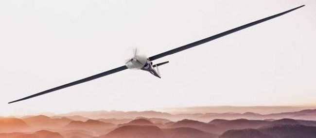
No worries. The sophisticated piece of carbon fiber, alloyed aluminum, and engineered plastic, gliding through the sky could care less about the temperature, though other atmospheric conditions are critical to monitor. Plus, the flying craft’s owners are seated comfortably in the climate-controlled command center, or more likely, lying in their canvas cots, trying to getting some rest.
This drone is a bargain compared to the other unmanned aerial vehicles (UAV’s) in the U.S. Military fleet. Utilizing an existing glider frame design from the commercial sector, then strapping on some proprietary government technology, this plane can be produced much faster, and cheaper, than the first generation, military surveillance, models.
Granted, this craft still comes with a $3 million price tag. And that’s before the transport fees from west coast North America to central Africa. Unfortunately, it can’t just fly itself all the way here. Yet.
The functionality of U.S Military drones has come a long way since the initial, unsophisticated, UAV’s of the 1990’s. Considering the $5 billion spent annually on R&D and procurement in this sector by the Defense Department, one would hope the technology is advancing at a rapid rate. Fortunately, it is.
This unmanned, unrestrained, unique craft has been circling the deserts of Northern Africa and the Middle East for two days. Completely autonomous, the route was programmed with various waypoints and surveillance tasks by Air Force personnel, then the silent bird was released into the wild.
The ultra-long-range capabilities, enabled by extreme light-weighting, electronics efficiencies, and battery storage improvements, allows discreet reconnaissance of regions which were previously out of reach, due to the risks posed by putting human-piloted airplanes in enemy airspace. Now, using this type of drone, nearly every location in the world is accessible, from one of America’s strategically placed bases.
Ongoing efforts are being made to develop autonomous airplanes for battle damage assessment, medium payload bomb delivery, and even air-to-air fighter jet combat. However, with the currently available technology, these long-distance surveillance gliders are the crown jewel of the Air Force’s UAV fleet.
Onboard, precise, satellite-based, GPS allows for coordinated flight anywhere around the globe. The high elevation capabilities, minimal noise or electronic emissions, and relatively small footprint of this craft, help mitigate detection in hostile airspace. The electronics on this drone are state-of-the-art: a high frequency data link, with anti-jamming capability, allows for constant communication with, and data downloads to, the central control center.
All this micro-processing technology can burn through a lot of energy, so one of the tricks on these extended missions is to optimize the sensors being used over different regions, and turn off those which are not needed.
Optical cameras during daylight hours provide insight on bustling port commerce activity in the Persian Gulf. Scanning radar can see through the dense clouds, allowing undetected, low altitude assessment of known Syrian insurgent camps. Nighttime infrared analysis shows the heat signatures around large oil operations, which dot the landscape in Iran. Onboard antenna arrays intermittently check the airwaves for communications of interest, be they friend or foe.
Each component has its own purpose, and functionality. When used as a cohesive system, a multitude of details about the geopolitics of the volatile Middle East region can be gathered in a single mission.
This reconnaissance trip has been a long one, covering over 15k nautical miles, travelling mostly above 50k feet. The power sources are nearly depleted, jet fuel and electronic batteries both running low, while the redundant memory banks are nearly full, with valuable intelligence material. Time to head home.
Somewhere on the ground below is a secret Air Force base. Completed just last year, and simply named #201, this facility is designed to blend into the drab African desert landscape. Despite the substantial efforts at camouflage, the drone’s navigation system knows exactly where to go.
Lining up with a seemingly invisible object on the smooth, flat, horizon, the airplane glides in gracefully. It’s made this approach nearly a dozen times in real life, with over a thousand runs in virtual simulations prior. However, desert winds are unpredictable; constant stabilization monitoring, with delicate wing flap adjustments, are needed to maintain a straight, level, flight path.
The inflated rubber tires touch the solid pavement gently, bouncing back into the air for an instant, then return to the ground for good. The glider comes to a stop silently, needing less than a third of the 4-mile-long runway, which is designed to accommodate massive C-17 cargo planes, not tiny, lightweight, aircraft.
The approach and landing are so quiet that strobing orange lights have been activated along the runway to inform unsuspecting humans of the incoming object, lest they wander out onto the tarmac. However, at this predawn hour, there’s little activity from the nearly 3k total American troops and local Niger recruits who operate the base. No matter, this drone knows where to go.
Powering forward slowly with its last remaining energy resources, the front nose wheel rotates slightly, causing the plane to track a wide arc across the asphalt, and perfectly through the open bay door at the far end of a massive airplane hangar, which is covered in sheet metal, painted tan to match the desert landscape. Another stealth mission complete.
Asia: Marina South, Singapore = UTC +8
The arena is dark, aside from the dim ambient starlight passing through the domed glass ceiling. Suddenly, at the flip of a switch, a sporadic pattern of neon lights engages throughout the cavernous interior space. Seemingly floating in space, the bright colors identify various geometric shapes: circles, rectangles, and triangles, outlined in vivid pink, green, and yellow.
On cue, spotlights beam down from the arcing steel rafters high above, illuminating 4 platforms, where seemingly innocuous pieces of black plastic sit. Briefly.
From the anticipatory silence a dull whir starts, quickly ramping up to a feverish buzz that a large swarm of bees would be jealous of. Within a second, these remote flying crafts, which can generate over 15 pounds of thrust, are traveling nearly 90 mph.
4 small points of lights emerge, growing larger as the object’s speed increases. As these mobile devices approach the first waypoint, a 6-foot square of glowing neon, their own flashing beacon markings having resolved to an X-shape, two colorful LED bars which cross each other.
Combinations of blue, red, and white pulse; each vessel has its own unique color signature. With nearly a thousand discrete LED’s on board, there’s plenty of opportunity for customization.
Realizing the race has started, the live crowd roars to life, their cheers drowning out the high-pitched whine of the rapid RPM propellers. This is the first Drone Racing League event ever held on Asia soil, and the locals, with their excitement for all things related to electronic gaming, have instantly adopted this new e-sport.
The 4 drones track one another, jockeying for position around sharp turns, plunging drops, and inverted loops. The world’s largest greenhouse, appropriately nicknamed the “Flower Dome”, seems like an odd place to host an event involving high speed, and unpredictable projectiles, but only adds to the excitement.
Along their route, the aerial machines buzz by a row of shrubs lining the pedestrian pathway, passing close enough for their wake to ruffle the pedals of numerous exotic tropical flowers, and weave between the trunks of tall palm trees, which serve as fixed course obstacles. To an unknowing observer, this entire scene resembles turbocharged fireflies flitting through a massive patio garden.
However, these flying objects are much more advanced, and much faster, than a typical insect.
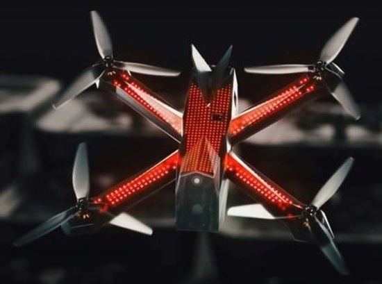
These drones are incredibly powerful, and thus, incredibly quick. True engineering marvels. Tri-fin propellers are attached to the 4 endpoints of their frame, which resembles a “+” sign. At the intersection of these arms, sits the compact body of the machine.
The craft’s styling is sleek and clean: aerodynamic, facetted, surfaces of injected plastic. The V-shaped rear fin serves as a stabilizing rudder, promoting the 45° angle, leading edge forward, orientation which offers max vehicle speed.
While the exterior of the drone is precise and functional, the real technology is housed within the main body of the craft. These flying devices are controlled remotely by athletes using sophisticated virtual reality headsets.
Due to the rapid, dynamic, motion, a delay of just a few milliseconds can be costly, so the wireless link occurs with no latency, utilizing high-tech antennas for data communication. In addition, the radio system allows for course tracing and diagnostics, no matter how complex the flight path gets.
The entire race lasts just over a minute, but there is no shortage of excitement during this time.
In the last section of the course, as the pressure to win mounts, the drone operators start to take risks, some successful, others with catastrophic consequences.
One drone cuts the inside of a sharp left turn a little too closely, the tip of the inner propeller clipping the protected vertical florescent light bar defining the course’s route. At these speeds, it’s impossible to stabilize the craft in time. Oblivious to the driver’s agitated joystick commands, the vehicle careens into the rope netting installed to protect the viewing fans from flying shrapnel. Startled gasps emanate from the closest patrons.
Rebounding off the net, the unstable object crashes to the tile floor of the patio, shedding an electronics cover, and two propellers, on impact. These parts, like most of the drone’s construction, are made with impact resistant polycarbonate, a tough, durable, plastic.
Racing drones are designed to crash, it’s inevitable in this sport, so their engineered modularity allows technicians to get a craft back up and running after even the harshest impacts. In fact, the efforts of these workers ensure each competitor gets an identically functioning rig. No small feat, considering the 500 drones in their rotating stable for each tour stop.
Meanwhile, the remaining trio is rushing onward. The 3 drone captains are transfixed, watching the onboard video image, and deftly manipulating their craft through the first-person view feed into their goggles. The live crowd, several thousand strong, are equally transfixed, using their own eyes for monitoring, as the rapidly moving points of light approach the finish line.
After some post production, incorporating video feeds from over 50 discrete cameras, the entire drone race, complete with operator perspective, will be broadcast globally across the internet, to over 10 million fans. For now, only those in attendance get to know the winner of this DRL Championship finale. At least until the results get tweeted out.
South America: La Jalca, Hualgayoc, Peru = UTC -5
In the center of the crushed gravel road sits a highly visible obstruction. The object is bright orange, like a road cone, or construction vest, both of which are quite common in this industrial mine setting. However, this entity is much more dynamic than those static safety items.
Viewed up close, certain features start to take shape. Thin, broad, panels, roughly a half meter square, extend vertically outward from the cylindrical core. Every part of the device is covered with reflective orange paint, except for a triangular stand in the middle, and two thin posts at the extremities, which are bright white. These are presumably meant to keep the object upright in the inevitable winds which often buffet this mountainous region.
Clarity finally arrives, as the device comes to life with a quiet whir. Within seconds, two previously static projections attached to the top of the flat panels are spinning too fast to be identified by the naked eye. The craft teeters for a second on the rocky ground, the machine’s upward force matching its weight, then gravity is defeated, and the highly visible body climbs vertically skyward.
Here at nearly 4k meters above sea level, in the northern section of the Andes Mountain range, the air is thin. So thin that custom propellers, with a wider blade, and more aggressive twist, are required to gain purchase on the low-density atmosphere.
This same phenomenon also requires the craft to fly faster than it normally would, to maintain the required constant speed and elevation which are essential for accurate surveying of the landscape below.
Reaching the desired height, 300 meters above its starting location, aggressive angling of the wing flaps transitions the plane seamlessly from vertical to horizontal. This fixed wing drone is much more comfortable, and efficient, flying parallel to the ground.
However, the vertical take-off capability allows the machine to be launched anywhere a small patch of empty ground can be found, rather than requiring a traditional long, flat, smooth, runway strip, a decided challenge in this rugged terrain.
Settling in at a steady 12 m/s speed, feedback loops adjusting the propellers for speed, and flaps for elevation, in the blustery alpine conditions, the electronic optics spring to life, and begin documenting the countryside below, via a series of focused, still-frame, images. This done carries an advanced 42-megapixel optical camera with wide sensor field of view, which speeds up the data capture process dramatically, and improves the resolution.
The large, open pit, mining area below is over 700 meters in diameter. Starting from the 4k meter peak on the east edge of the site, the excavation steps down in 10-meter benched sections, giving the illusion of a concentric topographic map carved onto the earth’s surface from this aerial perspective. The mining road snakes up from the center of the pit, taking a circuitous route, with several switchbacks, to maintain the 10% maximum grade allowable for fully loaded dump trucks.
The watchful camera eye of the drone is capturing all of these features as it glides noiselessly high overhead: every stockpile’s volume, every crest’s shape, every tailing pond’s location.
This region is rich in both copper and gold ore, so the plan is to expand the mine to over 1,000 meters across over the next few years. Having the accurate geological details this flying craft can provide will help leadership decide which regions to blast, excavate, crush, and extract next. To remain profitable, efficient mining practices are critical, and this flying machine is aiding in that endeavor.
The flight path consists of multiple parallel, slightly overlapping, runs to cover the entire mine site; each allows a 100-meter-wide swath to be imaged and documented in pristine detail. The optical pictures taken in flight are time and location stamped to the GPS position of the drone.
Cross-referencing a few key, known, fixed-point, features on the ground below, such as the tool shed roof, mountain peak flag, and crusher conveyor belt, allows determination of absolute geospatial location, at incredible precision.
Scanning of the entire 100-hectare site complete, the machine automatically reorients to vertical mode, then begins the self-imposed decent, adjusting the propeller rotation speed, and thus lift force, to avoid a gravity-driven free-fall decent. It’s like watching the launch played in reverse, with the drone eventually alighting back on the dusty road, in the nearly identical spot to where it took off just 45 minutes earlier.
The vertical landing technique has the added benefit of the protecting the belly of the craft, which houses the expensive, powerful, camera, from damage. On a typical glider approach, the same optical lens used to take the high-resolution pictures of the landscape would be exposed to scratching and breakage during a bumpy, skidding, reentry. In this instance, the camera sits safely, half a meter off the stony quarry floor.
Original machinery, and newly acquired data, having returned safely to earth, the next step is to download the massive image files, and run them through sophisticated photogrammetry software. Within an hour, engineers will have a highly detailed 3D mesh map of the entire mine facility, with positional resolution under 3 cm.
The directive for the next blasting excavation will be available by the end of the day. This mountain mining site has been consistently recovering gold and copper ore for the past 5 years, and plans to continue doing so by incorporating any new technology available. Their shiny orange surveying drone is indispensable in this regard.
Oceania: Bora Bora, French Polynesia = UTC -10
Crystal clear, turquoise blue, ocean extends out from the white sand beach. The sun is slightly past vertical in the cloudless sky, a deeper, more opaque, blue than the water. Somewhere, far off in the distance, these two soothing tones meet in a thin line which marks the horizon.
Closer afield, a traditional Polynesian outrigger canoe, hand carved hardwood, with bamboo accoutrements, glides slowly across the translucent calmness of the bay. A small drone tracks closely behind the boat, 3 meters off the water, matching the gentle pace of the floating object.
This setup provides a unique, stable, follow-camera, perspective. The green-black mass of Mount Otemanu rises from the center of the island, helping to frame the shot, and provide scale to the majestic beauty of this place. A picturesque setting indeed.
As the front of the boat gently nudges the shore, the drone continues its slow forward motion, while also increasing the propeller rate to rise up to a height of 10 meters. At this elevation, the moderate whine of the motors is imperceptible to the humans below. The goal of this device is to be as stealthy, and non-invasive, as possible.
The higher position also offers a wider field of view, allowing the pending series of activities on the beach below to be captured in a single, framed, shot.
The canoe’s paddler, a bare-chested, darkly tanned, Tahitian local, quickly jumps out of the boat, steadying the vessel as he pushes it ashore. Simultaneously, a second gentleman, clad in a loose-fitting white suit of soft silk, steps forward toward the now-beached craft, and the seated occupant within.
Sensing the importance of this moment, the drone operator adjusts the two tiny joysticks on the remote, with a pair of opposable thumbs, zooming the high-resolution camera in, while simultaneous tweaking the air position slightly. The virtual reality headset worn by this professional photographer displays exactly what the aerial machine’s camera is recording, making it seem as if she is perched on top of this tiny flying device.
The computerized image currently shows a man reaching down, and helping a woman, dressed in a flowing white gown, out of the canoe, and onto the sand. The lady’s smile is beaming, her cheeks flushed with passion, her tussled brown hair pinned up, and secured with a crown of white tiare tahiti flowers.
It’s amazing how stable the camera is, even at high resolution zoom. Every bead of sweat, every individual floral petal, every shimmering sequin on the gown, is being documented.
As the couple walk forward on the beach, the drone and its commander use the downtime to change positions. This device, less than a kilogram in total weight, and only 300 cm on its longest dimension, is nearly invisible relative to the beauty, and excitement, of the wedding ceremony below.
The drone laws here in Bora Bora, a French territory, are quite strict, requiring operators to get a special UAV pilot’s license. The airspace risks are numerous, with the small local airport frequently yielding low flying planes, and the numerous helicopter tour companies constantly buzzing the beach. It’s a challenging landscape for the amateur drone user. That’s why the aerial photography business is so lucrative on this destination resort island.
The contrast of colors on the ground below offers a natural, picturesque, frame. Laid out in the shimmering white sand is a heart shape, composed of vibrant yellow, orange, and red hibiscus flowers, and vivid, leafy green, palm fronds, both native to the region. Ringing this perimeter are the wedding guests.
As the couple approaches the circle, they are met with the traditional greeting, a deep, guttural, call from a conch shell, or “Pu” in the local dialect, which identifies the arrival of the dignified pair, especially the bride, to all in attendance.
This song is also a summoning of the 4 Polynesian gods of earth, representing land, air, fire, and sea, to the ceremony. Fortunately, the horn’s deep notes are on a significantly different frequency than the drone’s high-pitched humming propeller noise, a sound which can be removed from the video during post-processing.
Content with the filming position, the operator toggles from “sport” to “tripod” mode; this reduces the drone’s maximum speed and mobility, but places a priority on stability in the air, using gyroscopic sensors to monitor and constrain the flying object’s 6 degrees of freedom, 3 translational and 3 rotational.
With the flight adjustments now on autopilot, the photographer can focus on her artistic presentation. As the director turns her head, the sensors in the VR goggles recognize the motion, and pan the camera accordingly. The drone’s optics are now an extension of the user’s eyes, remotely mimicking human movements with electronic controls.
The setting is perfect. The sun is high, and behind the aerial camera, thereby providing optimal backlighting. The N16 polarizing filter over the lens helps to minimize glare off the reflective sand crystals on this brilliantly bright summer day.
The optical electronics mounted underneath the hovering craft toggles between video and still images, per its master’s bidding. Based on drone photography experience gleaned over time, she’s using manual film mode, with many of the key camera settings already dialed in. Aperture at F/4, near the low end of the functional range. ISO set to 100, to promote a crisp picture on this sunny afternoon. Filming in 4k HQ, at 30 frames per second, in case any rapid motion activities need to be captured.
Now, it’s time to document the key moments of the wedding.
A close-up of the Tahua, the Tahitian priest overseeing the ceremony, in ancient garb of red, yellow, and black, including a huge, feathered, headdress. A video of the traditional binding of the couple’s wrists with Auti, the native, fibrous, green, lily leaves, then pouring of coconut water over the clasped hands, with commentary provided in both English, and native Polynesian, by the colorful orator. And, most important, the embrace and kiss which seals the deal, at several different zoom ranges, with the lovers wrapped in a handmade Tifaifai blanket.
The ceremony is simple, short, and traditional. Good thing, because the drone’s battery is running low, on account of all the B-roll footage filmed earlier, plus the many camera and position adjustments needed to attain the perfect shots. It’s important to capture every element of the event flawlessly on this special day.
However, the flashing red light on the VR display, the sensory rumble of the hand-held controller, and the sputtering of the drone’s propulsion systems, though its still high in the sky, all suggest that power has been fully depleted.
As the hovering electronic device goes into automated safety return mode, it descends vertically downward as gently as possible on the waning batteries. This turns out to still be quite rapid. Fortunately, the essentially free-falling object is well clear of the wedding party. Unfortunately, the unplanned landing spot is going to be right in the middle of the 3-piece island band hired to send the newlyweds off in style.
As reality sets in, there’s a mad scramble on the ground below; a slack-key guitar, a squatty hand drum, a polished wood ukulele, and three young lads, all go flying in different directions, seeking safety. The projectile misses them all, plopping down less than a foot from where the drummer’s abandoned wicker stool sits.
Good thing this drone is equipped with the leg extension package for soft surface moorings. The critical camera, and invaluable footage, are safely perched just inches off the white sand, after that impromptu, harsh, landing. The only casualty is a colorful lei, discarded by one of the band members as he scrambled for cover, which is now pinned under the drone’s plastic front feet.
Another crisis averted. Those could have been guests at the wedding.
